The concepts of “weather” and “climate” are often confused. Meanwhile this different concepts. If weather represents the physical state of the atmosphere over a given territory and on given time, then climate is a long-term weather pattern that is maintained in a given area for centuries with slight fluctuations.
Climate - (Greek klima inclination (of the earth's surface to the sun's rays)), statistical long-term weather regime, one of the main geographical characteristics of a particular area. N.S. Ratobylsky, P.A. Lyarsky. General geography and local history. - Minsk, 1976. - p. 249. The main features of the climate are determined by:
Incoming solar radiation;
Air mass circulation processes;
The nature of the underlying surface.
Of the geographical factors influencing the climate of a particular region, the most significant are:
Latitude and altitude of the area;
Its proximity to the sea coast;
Features of orography and vegetation cover;
Presence of snow and ice;
Degree of air pollution.
These factors complicate the latitudinal climate zonation and contribute to the formation of local climate variations.
The concept of “climate” is much more complex than the definition of weather. After all, the weather can be directly seen and felt all the time, and can be immediately described in words or numbers from meteorological observations. To get even the most approximate idea of the climate of an area, you need to live in it for at least several years. Of course, you don’t have to go there; you can take many years of observational data from a meteorological station in this area. However, such material consists of many, many thousands of different numbers. How to make sense of this abundance of numbers, how to find among them those that reflect the properties of the climate of a given area?
The ancient Greeks thought that climate depended only on the inclination of the elements falling on the Earth. sun rays. In Greek, the word climate means slope. The Greeks knew that the higher the sun above the horizon, the steeper the sun's rays fall on the earth's surface, the warmer it should be.
Sailing north, the Greeks found themselves in places with a colder climate. They saw that the sun at noon was lower here than at the same time of year in Greece. But in hot Egypt, on the contrary, it rises higher. We now know that the atmosphere transmits on average three-quarters of the heat of the sun's rays to the earth's surface and retains only one-quarter. Therefore, first the earth's surface is heated by the sun's rays, and only then does the air begin to heat up from it.
When the sun is high above the horizon (A1), a section of the earth's surface receives six rays; when lower, there are only four rays and six (A2). This means that the Greeks were right that heat and cold depend on the height of the sun above the horizon. This determines the difference in climate between the eternally hot tropical countries, where the sun is at noon all year round rises high, and twice or once a year stands directly overhead, and the icy deserts of the Arctic and Antarctic, where for several months the sun does not appear at all.
However, not at the same geographical latitude, even in the same degree of heat, climates can differ very sharply from each other. For example, in Iceland in January the average air temperature is almost
0°, and at the same latitude in Yakutia it is below -48°. In terms of other properties (amount of precipitation, cloudiness, etc.), climates at the same latitude can differ from each other even more than the climates of equatorial and polar countries. These climate differences depend on the properties of the earth's surface that receives the sun's rays. White snow reflects almost all the rays falling on it and absorbs only 0.1-0.2 parts of the brought heat, while black wet arable land, on the contrary, reflects almost nothing. Even more important for the climate is the different heat capacity of water and land, i.e. their different ability to store heat. During the day and summer, water heats up much more slowly than land and turns out to be colder. At night and in winter, water cools much more slowly than land, and thus turns out to be warmer.
In addition, a very large amount of water is spent on the evaporation of water in seas, lakes and wet land areas. solar heat. Due to the cooling effect of evaporation, the irrigated oasis is not as hot as the surrounding desert.
This means that two areas can receive exactly the same amount of solar heat, but use it differently. Because of this, the temperature of the earth's surface, even in two neighboring areas, can differ by many degrees. The surface of the sand in the desert on a summer day heats up to 80°, and the temperature of the soil and plants in the neighboring oasis turns out to be several tens of degrees colder.
Air in contact with soil, vegetation or water surface is either heated or cooled, depending on what is warmer - the air or the earth's surface. Since it is the earth's surface that first receives solar heat, it mainly transfers it to the air. The heated lowest layer of air quickly mixes with the layer lying above it, and in this way heat from the ground spreads higher and higher into the atmosphere.
However, this is not always the case. For example, at night the earth's surface cools faster than the air, and it gives off its heat to it: the heat flow is directed downward. And in winter, over the snow-covered expanses of the continents in our temperate latitudes and over the polar ice, this process goes on continuously. The earth's surface here either does not receive solar heat at all, or receives too little of it and therefore continuously takes heat from the air.
If the air were motionless and there was no wind, then masses of air with different temperatures would accumulate over neighboring differently heated areas of the earth's surface. Their boundaries could be traced to the upper reaches of the atmosphere. But the air is constantly moving, and its currents tend to destroy these differences.
Let's imagine that air moves over a sea with a water temperature of 10 ° and on its way passes over a warm island with a surface temperature of 20 °. Above the sea, the air temperature is the same as the water, but as soon as the flow crosses the coastline and begins to move inland, the temperature of its lowest thin layer begins to rise, and approaches the temperature of the land. Solid lines of equal temperatures - isotherms - show how heating spreads higher and higher in the atmosphere. But then the stream reaches the opposite shore of the island, enters the sea again and begins to cool - also from bottom to top. Solid lines outline a “cap” of warm air that is inclined and shifted relative to the island. This "cap" of warm air resembles the shape that smoke takes when strong wind. Budyko M.I. Climate in the past and future. - Leningrad: Gidrometeoizdat, 1980. - p. 86.
There are three main types of climates - large, medium and small.
The great climate is formed under the influence only of geographic latitude and the largest areas of the earth's surface - continents, oceans. It is this climate that is depicted on world climate maps. A large climate changes smoothly and gradually over large distances, at least thousands or many hundreds of kilometers
The climatic features of individual areas with a length of several tens of kilometers (a large lake, a forested area, a large city, etc.) are classified as an average (local) climate, and smaller areas (hills, lowlands, swamps, groves, etc.) - to a small climate.
Without such a division it would be impossible to figure out which climate differences are major and which are secondary.
It is sometimes said that the creation of the Moscow Sea on the Moscow Canal changed the climate of Moscow. This is not true. The area of the Moscow Sea is too small for this.
Different influx of solar heat at different latitudes and unequal use of this heat on the earth's surface. They cannot fully explain to us all the features of climates if we do not take into account the importance of the nature of atmospheric circulation.
Air currents constantly transfer heat and cold from different areas globe, moisture from the oceans to land, and this leads to the emergence of cyclones and anticyclones.
Although the atmospheric circulation changes all the time, and we feel these changes in weather changes, yet a comparison of different areas shows some constant local circulation properties. In some places, northern winds blow more often, in others - southern ones. Cyclones have their favorite paths of movement, anticyclones have theirs, although, of course, there are any winds in any place, and cyclones are replaced by anticyclones everywhere. Cyclones cause rain. Budyko M.I. Climate in the past and future. - Leningrad: Gidrometeoizdat, 1980. - p. 90.
| No. | Indicators |
| Air and soil temperature Average by month Average for the year Absolute air temperature Temperature of the coldest five-day period with a probability of 0.92 Average daily amplitude of air temperature of the coldest month Duration of the period with an average daily air temperature £ 8 ºС Average air temperature of a period with an average daily air temperature £ 8 ºС Average maximum air temperature of the warmest month Absolute maximum air temperature Average daily amplitude of air temperature of the warmest month Air humidity Average monthly relative air humidity of the coldest month Average monthly relative air humidity of the warmest month Precipitation Amount of precipitation for November - March Amount of precipitation for April – October Daily maximum precipitation Wind Predominant wind direction for December – February Predominant wind direction for June – August Solar radiation Amount of heat coming from direct, diffuse and total radiation to a horizontal surface Amount of heat coming from direct, diffuse and total radiation to a vertical surface |
Design standards are determined by probabilistic values, and the probability (probability) is set depending on the projected duration of operation of the structure. Thus, the outside air temperature in SNiP is given by the probability of 0.98 and 0.92.
Topic 2 Basic climate characteristics and their importance in design
Basic climatic characteristics
Construction climatology involves taking climate into account when solving architectural and construction problems, compiling climatic characteristics of the construction area in order to identify favorable and unfavorable climate factors for humans.
The climate of our country is diverse, its effects on humans and on the formation of the habitat are diverse. Without taking into account the climate, it is impossible to build economically, sufficiently durable; it is impossible to create conditions favorable for human activity.
Climate affects the durability of buildings - the duration of their operation, which is determined by the ability to withstand climatic influences. In order to neutralize negative climate factors and use positive ones, it is necessary, having studied the climate of the construction area, to select the most suitable building materials, in a known manner reacting to frost or heat, high or low humidity, resistant to corrosion, etc.; determine the layout of the building that provides the greatest comfort for people.
Climate indicators can be divided into two groups – general and special.
TO general indicators climate include: temperature (t, °C), humidity (w, %), air movement (u, m/s), solar radiation (P, W/m2).
Temperature - one of the most important climatic elements. Table 2 shows the temperature scales and their relationships.
Table 2
Temperature scales
Temperature in working hours day t avg dn depends on the average climate temperature for individual months of the year t avg month and the average amplitude of temperature fluctuations At n during the day and has highest value for thermal performance.
Taking into account the thermal effect on humans, the following types of weather have been identified:
– cold (below +8 °C);
– cool (8-15 °C);
– warm (16-28 °C);
– hot (above +28 °C);
– very cold (below -12 °C);
– very hot (above +32 °C).
Duration characteristic species weather throughout the year determines the main climate features that affect the structural and architectural solutions buildings.
The durability of a building depends on the condition of its main parts - the foundation, load-bearing walls or frame, enclosing structures. Under the alternating influence of heat and cold, structural materials are destroyed. More intense destruction occurs with rapid changes in temperature and, especially, with temperature changes with transitions through 0 ° C.
Therefore, when designing buildings, the following are taken into account:
– estimated temperature of the coldest day and five days;
– amplitudes of air temperature fluctuations – daily, monthly, annual.
Humidity air environment significantly affects the moisture state of structures.
To determine the humidity regime, the following indicators are used.
Absolute humidity f, g/m3, is the amount of moisture in grams contained in 1 m3 of air.
Partial pressure (elasticity) of water vapor e, Pa, - the pressure of g or steam mixed with other gases - gives an idea of the amount of water vapor contained in the air.
The state of complete saturation of air with water vapor is called saturation mill W, g/m3. The saturation point is constant at a given air temperature.
Partial pressure limit E, Pa, corresponds to complete saturation of air with water vapor.
With increasing air temperature, the values of E and W increase. E values for air with different temperatures are given in Table 3.
Table 3
Values of the maximum partial pressure of water vapor E, Pa, for different temperatures(at atm. pressure...)
Relative humidity j characterizes the degree of air saturation with water vapor and is defined as the ratio of absolute humidity to the saturation point at a constant temperature:
Relative air humidity can be defined as the ratio of absolute partial pressure to partial pressure in the saturation stage:
The value of j affects the intensity of moisture evaporation from any moistened surfaces.
According to the value of j, they distinguish humidity conditions premises:
dry (j<50%);
normal (j=50¸60%);
wet (j=61¸75%);
wet (j>75%).
With increasing air temperature, relative humidity j decreases, the value of partial pressure e remains constant, and the value of E increases, since warm air may be more saturated with moisture vapor than cold.
As the temperature decreases, the relative humidity j increases and can reach 100% and at a certain temperature it may turn out to be E = e, a state of complete saturation of the air with water vapor occurs. The temperature at which the air becomes completely saturated with water vapor is called dew point temperature t r . With a further decrease in air temperature t in the room, the excess moisture turns into a liquid state - it condenses, and settles in the form of a liquid on the fence.
The value of j affects the processes of moisture condensation in the thickness and on the surface of the fence, and the moisture content of the fence material.
Example for determining dew point:
High humidity air impairs the performance of structures, reduces their service life and negatively affects the microclimate of the premises. When designing, a calculation is made of possible moisture and condensation formation on the surface or in the thickness of the fence.
The combination of temperature and air humidity determines the comfort of indoor conditions. Requirements for comfort conditions are established in sanitary and hygienic standards, taking into account climatic region construction. This is explained by the peculiarities of the influence of climate on the human body in different conditions. In areas with cold winters, normalizing the thermal state of a person in a home requires more high temperature indoors than in warm areas.
Depending on the climate, the ratio of temperature and humidity of the outside air and indoors, the movement of water vapor through the fence occurs outside or inside the premises.
For example, in Moscow, during the year, the outdoor air temperature (Table 4) rarely exceeds the indoor temperature (18 °C); the heat flow to the outside predominates. Absolute air humidity of 50–60% indoors is higher most of the year than outside (Table 5), therefore, the movement of water vapor from the indoors to the outside predominates. As a measure to prevent condensation dampening of fences, in Moscow a waterproofing layer is provided closer to inside walls (to the wettest area of the fence).
Table 4
Average monthly and annual air temperature, °C
Table 5
Humidity and precipitation
Therefore, it is impossible to automatically transfer preventive measures from one area to another, without taking into account the characteristics of the climate, namely, temperature and humidity.
Number of drops precipitation and their intensity are of great importance in design. The influence of precipitation on building enclosures is significant.
When it rains with strong gusty winds, the walls become wet. During the cold season, moisture moves inside the structure from colder and wetter layers to warmer and drier ones.
If the fencing is lightweight, moisture can reach the inner surface of the wall. If the walls are massive, moisture does not penetrate into the room, but such walls dry out slowly, and when the temperature drops, the moisture inside the structures freezes and destroys the walls. Destruction is accelerated by thaws. Long-term drizzling precipitation has a more harmful effect than intense, short-term precipitation in the form of small drops. Small drops are held on the surface and absorbed by materials. Large drops roll off the walls under the influence of gravity.
Precipitation (rain, melting snow) increases soil moisture, the level rises groundwater. This is dangerous for buildings due to the possibility of soil swelling and flooding of the underground part of the building.
The amount of snow that falls increases the load on the roofs of buildings. When designing coatings, the possibility of intense snowfalls that create short-term loads is taken into account.
Wind has a direct impact on buildings. From direction and speed air flow depends on the temperature and humidity conditions of the area. The heat transfer of buildings depends on wind speed. Wind conditions affect the layout, orientation of buildings, the placement of industrial and residential areas, and the direction of streets.
For example. In Siberia and the Urals inner surface outer wall, located perpendicular to the cold wind, is somewhat colder than when there is a calm. In Murmansk, in winter, apartments with windows facing south are colder than those facing north, because the south wind is colder there. In hot climates, the arrangement of rooms can achieve cross-ventilation of apartments, i.e. the wind improves the microclimate of the home. In humid areas, wind speeds up the drying of fences, thereby increasing the durability of buildings.
Radiant energy from the sun (solar radiation) creates natural illumination of the earth's surface. Solar radiation can be defined as the amount of energy per unit surface, W/m2.
The spectrum of solar radiation consists of ultraviolet rays (about 1%), visible rays, which give light (about 45%), and infrared rays, which heat (about 54%).
Only part of the solar radiation reaches the earth's surface: direct, scattered and reflected.
The amount of total (direct and diffuse) solar radiation is given in SNiP for horizontal and vertical surfaces.
Exposure of any surface to direct sunlight is called insolation. Insolation of a territory or room is measured by the duration in hours, the area of irradiation and the depth of penetration of sunlight into the room.
The positive effect of insolation is determined by the bactericidal properties of sunlight and thermal effects.
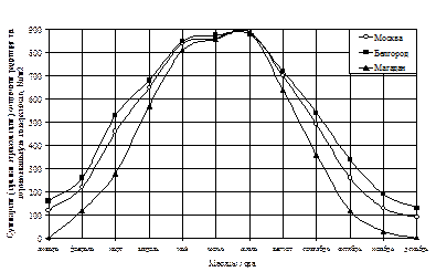 |
The amount of solar radiation also depends on the latitude of the construction area, the time of year and has its maximum intensity in the summer (Figure 2).
Figure 2– Comparison of solar radiation intensity.
The heating of the walls and the temperature inside the premises depend on the amount of incoming solar radiation. When the windows are open, the same amount of heat enters the room as the walls. At closed windows Some of the radiation is reflected from the glass, some is absorbed by the glass and window frames, heating them. With single glazing, about half of the incident radiation (41–58%) penetrates through the window; with double glazing, about 1/3 of the radiation (23–40%) penetrates through the window.
When considering the effect of solar radiation on a building, absorption capacity should be taken into account various materials, which depends on their color and condition. Table 6 shows the absorption capacity of various materials.
As already noted, this concept refers to the climate after the warming of the 30s and 40s. This period is characterized by a general decrease in temperature, an increase in the amount of ice and snow on the continent, and the recurrence of unusual weather conditions, i.e., those that, according to the WMO, occur once every 25-30 years or more. There were also individual climate warmings, for example in the late 50s; it then gave way to significant cooling, peaking in the mid-60s. Following this, an increase in temperature was recorded, lasting until the late 60s and early 70s. This fact has led some scientists to argue that this is global warming and marks a turning point in the climate trend towards global warming due to anthropogenic factors and, in particular, due to the increase in CO 2. However, such statements turned out to be premature, for at least two reasons.
Firstly, in the mid-70s, the trend towards a cooling climate reappeared, and the years 1976, 1978, 1979 were exceptionally cold and abnormal in terms of the number of unusual weather conditions (droughts, cold winters, floods). In this regard, the warming of the late 60s - 70s should be considered the same climate fluctuation as before.
Secondly, the climate cooling after the 40s was not widespread, but had a clearly defined regional character, which was observed in all periods of the Earth’s history. As for the growth of CO 2, it does not yet provide the greenhouse effect that can explain the warming. Moreover, this factor is not the only one.
In 1973, the Japan Meteorological Service established a special research group to assess the frequency of unusual weather conditions and climate change trends. A large number of experts believe that the change is not average climatic conditions, and climatic anomalies, climatic extremes or unusual weather conditions mainly affect the state of human society.
In table Table 3 shows data from Japanese researchers on the frequency of unusual (high and low) temperatures and precipitation for 1961-1972.
The table shows that during the specified period, the number of cases with unusually low average monthly temperatures (460 months versus 206) and precipitation (472 versus 295) prevailed.
For 1960-1969 compared to the warming period 1920-1940. The frequency of unusually low temperatures increased by almost 2 times, and the frequency of high temperatures decreased by the same amount. The decrease in surface temperature in the North Atlantic from 12.03 to 11.043 ° C from 1951 to 1972, an increase in the area occupied by ice and snow. According to observational data, this area from 1950 to 1973 increased from 33 to 39 million km 2 After the 40s, mountain glaciers began to advance again. Studies in the United States of 73 small glaciers that quickly respond to climate change showed that during 1953-1955. 50 glaciers were in the advancing stage, 14 were accumulating their thickness without noticeable movement, and only 7 were in a stationary state. At Canadian mountain polar stations, the average zero isotherm for July in 1964-1972. was 276 m lower than in 1955-1963.
With climate warming from 1880 to 1930 over the British Isles, the number of days per year with westerly winds increased from 85 to 110, and then with cooling until the early 70s it decreased, reaching 80, and by the mid-70s - 68.
It must be said that climate warming in Europe associated with an increase in the intensity of west-east transport has been recorded quite clearly. In the circulation processes of the modern period, the blocking of west-east transport with sharp fluctuations in weather conditions is more often repeated.
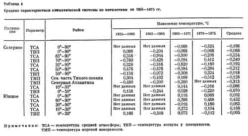
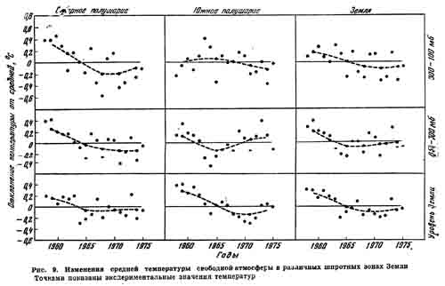
In table 4 shows data on the change individual characteristics climate system for the 50-70s. On average, there was a decrease in the temperature of the middle troposphere of the northern hemisphere, especially in the temperate zone and high latitudes. Less clearly, but quite clearly, there is a tendency for the air temperature to decrease at the surface, which experiences significant fluctuations. Temperatures rose slightly in the late 60s and early 70s. Cooled off surface layer both in the Atlantic and Pacific Ocean. Amount of snow and ice per recent years has increased. In the southern hemisphere, a different picture appears to have been observed. Thus, the temperature of the middle atmosphere increased slightly. The air temperature at the surface also changed slightly. The amount of pack ice in Antarctica first increased slightly and then began to decrease. The vorticity index of atmospheric processes characterizes the increased instability of circulation over the period under consideration. Some idea of temperature changes in different zones and layers of the northern and southern hemispheres is given in Fig. 9.
Analyzing the data presented, two conclusions can be drawn.
1. In the northern hemisphere, snow and ice cover continues to increase and temperatures decrease at an average rate of approximately 0.2 ° C per 10 years, which is confirmed by almost all characteristics of the climate system. There are no serious reasons, with the exception of some upward temperature fluctuations in the late 60s - early 70s, to conclude that global warming There is no climate of the last period.
2. In the southern hemisphere, the climate is warming somewhat and the amount of ice is decreasing.
Modern climate unstable: droughts in some areas and floods in others. Such instability was characteristic of the Little Ice Age transition in the past.
So, in general, the following can be said about the modern climate.
1. Currently, there is a trend of climate cooling in the northern hemisphere, which is characterized by an average decrease in air and water temperatures by 0.1-0.2 ° C over 10 years and an increase in the amount of ice and snow. Apparently, this cooling is not a sign of a transition to a new ice age, but a climatic fluctuation similar to the past. The climate is warming in the southern hemisphere.
2. The frequency of unusual weather conditions and climatic anomalies is increasing. This happened earlier, in particular during the transition from the small climatic optimum to the small ice age and during the latter. Therefore, we can hardly talk about the exceptional anomalousness of the observed conditions. However, now, unlike in previous centuries, they cover densely populated areas with highly developed economies, and therefore the consequences of such climatic anomalies may be more noticeable than in the past.
3. Increased variability of climate and especially temperatures is most intense, as before, in high and moderate latitudes and to a lesser extent in low latitudes.
4. Increased variability of precipitation is manifested in all latitudinal zones, but is most noticeable in the so-called arid zones and adjacent zones, because agriculture in these areas suffers greatly from droughts or even lack of precipitation.
5. The economy and man himself at all times, and especially recently, depend both on climatic trends in average temperatures, average precipitation, and, to an even greater extent, on climatic anomalies and climate variability. Studying these conditions in the future and predicting them will become main task when assessing and taking into account the impact of climate on the economy and human activity.
As one example, we provide data on the length of the growing season (days when the average temperature is above 5.5 ° C) in central England. In 1870-1895. the average duration of the growing season for a decade was 255-265, and the shortest was 205-225 days; in 1930-1949 respectively 270-275 and 237-243 days. In 1950-1959 the average duration of the growing season fell again to 265, and the minimum to 226 days.
During the coldest decades of the Little Ice Age in England, the average growing season was shorter by almost a month compared to 1930-1949. The superposition of major climatic anomalies on epochs of a shortened growing season can significantly aggravate the consequences of already unfavorable climatic conditions caused by a shortening of the growing season.