It is possible to determine the location of a point on planet Earth, as on any other spherical planet, using geographic coordinates - latitude and longitude. The intersections of circles and arcs at right angles create a corresponding grid, which allows you to unambiguously determine the coordinates. A good example is an ordinary school globe, lined with horizontal circles and vertical arcs. How to use the globe will be discussed below.
This system is measured in degrees (degree of angle). The angle is calculated strictly from the center of the sphere to a point on the surface. Relative to the axis, the degree of latitude angle is calculated vertically, longitude - horizontally. To calculate exact coordinates, there are special formulas, where another quantity is often found - height, which serves mainly to represent three-dimensional space and allows calculations to be made to determine the position of a point relative to sea level.
Latitude and longitude - terms and definitions
The earth's sphere is divided by an imaginary horizontal line into two equal parts of the world - the northern and southern hemispheres - into positive and negative poles, respectively. This is how the definitions of northern and southern latitudes were introduced. Latitude is represented as circles parallel to the equator, called parallels. The equator itself, with a value of 0 degrees, acts as the starting point for measurements. The closer the parallel is to the upper or lower pole, the smaller its diameter and the higher or lower the angular degree. For example, the city of Moscow is located at 55 degrees north latitude, which determines the location of the capital as approximately equidistant from both the equator and the north pole.
Meridian is the name of longitude, represented as a vertical arc strictly perpendicular to the circles of parallel. The sphere is divided into 360 meridians. The reference point is the prime meridian (0 degrees), the arcs of which run vertically through the points of the north and south poles and extend in the east and west directions. This determines the angle of longitude from 0 to 180 degrees, calculated from the center to the extreme points to the east or south.
Unlike latitude, the reference point of which is the equatorial line, any meridian can be the zero meridian. But for convenience, namely the convenience of counting time, the Greenwich meridian was determined.
Geographic coordinates – place and time

Latitude and longitude allow you to assign a precise geographic address, measured in degrees, to a particular place on the planet. Degrees, in turn, are divided into smaller units such as minutes and seconds. Each degree is divided into 60 parts (minutes), and a minute into 60 seconds. Using Moscow as an example, the entry looks like this: 55° 45′ 7″ N, 37° 36′ 56″ E or 55 degrees, 45 minutes, 7 seconds north latitude and 37 degrees, 36 minutes, 56 seconds south longitude.
The interval between the meridians is 15 degrees and about 111 km along the equator - this is the distance the Earth, rotating, travels in one hour. It takes 24 hours to complete a full rotation of a day.
We use the globe

The model of the Earth is accurately depicted on the globe with realistic depictions of all continents, seas and oceans. Parallels and meridians are drawn on the globe map as auxiliary lines. Almost any globe has a crescent-shaped meridian in its design, which is installed on the base and serves as an auxiliary measure.
The meridian arc is equipped with a special degree scale by which latitude is determined. Longitude can be found out using another scale - a hoop mounted horizontally at the equator. By marking the desired location with your finger and rotating the globe around its axis to the auxiliary arc, we fix the latitude value (depending on the location of the object, it will be either north or south). Then we mark the data on the equator scale at the point of its intersection with the meridian arc and determine the longitude. You can find out whether it is eastern or southern longitude only relative to the prime meridian.
The ability to determine where latitude or longitude is on a map is important for a person. Especially when an accident occurs and you need to quickly make a decision and transfer coordinates to the police. They recognize her different methods. They mean the angle that is the plumb line and the 0 parallel at a predetermined point. The value is only up to 90 degrees.
Don't forget that the equator divides the earth into the northern and southern hemispheres. Therefore, the latitude of points on earth that are higher than the longest parallel is northern, and if they are located lower, then southern.
How to find out the latitude of any object?
You can determine latitude and longitude on a map. Look at which parallel the object is indicated. If it is not indicated, then independently calculate the distance between neighboring lines. Then find the degree of parallel you are looking for.

At the equator, geographic latitude is 0°. Points that on the same parallel will have the same latitude. If you take a map, you will see it on the frames; if it is a globe, then where the parallels with the 0° and 180° meridians intersect. Geographic latitudes range from 0° and only up to 90° (at the poles).
5 main latitudes
Take a map, you will see the main parallels there. Thanks to them, coordinates are easier to recognize. From the latitudinal line to the line, the territories are located. They belong to one of the regions: temperate or equatorial, polar or tropics.
The equator is the longest parallel. Lines that are lower or higher decrease towards the poles. The latitude of the equator is 0°. This is the point from which parallels are calculated towards the south or north. The area that starts from the equator and extends to the tropics is the equatorial region. The northern tropic is the main parallel. It is always marked on world maps.

The exact coordinates of 23° 26 min can be detected. and 16 sec. north of the equator. This parallel is also called the Tropic of Cancer. The Tropic of the South is a parallel located at 23° 26 min. and 16 sec. south of the equator. It is called the Tropic of Capricorn. The area that is located in the middle of the line and towards the equator is tropical regions.
At 66° 33 min. and 44 sec. The Arctic Circle is located just above the equator. This is the border, beyond which the length of the night increases. Near the pole it is 40 calendar days.
Latitude of the South Arctic Circle -66° 33 min. and 44 sec. And this is the border, and beyond it there are polar days and nights. The regions between the tropics and the described lines are temperate, and those beyond them are called polar.
Instructions
Step #1
Everyone knows that the equator divides the earth into the southern and northern hemispheres. There are parallels beyond the equator. These are circles that are parallel to the equator itself. Meridians are conventional lines that are perpendicular to the equator.

The Prime Meridian passes through the observatory, it is called Greenwich and is located in London. That’s why they say: “Greenwich Meridian”. The system, which includes parallels with meridians, creates a coordinate grid. It is used when they want to determine where an object is located.
Step #2
Does geographic latitude indicate that a given point is south or north of the equator? It defines an angle of 0° and 90°. The angle begins to be calculated from the equator and towards the south or north pole. This way you can determine the coordinates; they say that the latitude is south or north.
Step #3
Geographic coordinates are measured in minutes and seconds, and most importantly - in degrees. A degree of a certain latitude is 1/180 from any of the meridians. The average length of 1 degree is 111.12 km. A minute in length is 1852 m. The diameter of Mother Earth is 12713 km. This is the distance from pole to pole.

Step #4
To find out latitude using the described method, you need a plumb line with a protractor. You can make a protractor yourself. Take several rectangular planks. Clamp them together like a compass so that they change the angle between them.
Step #5
Take the thread. Hang a weight (plumb) on it. Secure the string to the center of your protractor. Point the base of the protractor at the Polaris star. Do some geometric calculations. Specifically, from the angle between the plumb line and the base of your protractor, immediately subtract 90°. This result is the angle that passes between the polar star and the horizon. This angle is the geographic latitude where you are.
Another way
There is another option for finding the coordinates. It's not like the first one. Wake up before sunrise and time its beginning, and then sunset. Take a monogram in your hands to find latitude. On the left side of the monogram, write down how long the daylight hours lasted, and on the right side, write the date.

Back in the middle of the 18th century. similar coordinates could be determined on the basis of astronomical observations. In the 20s 20th century it is already possible to contact by radio and determine coordinates special tools.
800+ notes
for only 300 rubles!
* Old price- 500 rub.
The promotion is valid until 08/31/2018
Lesson questions:
1. Coordinate systems used in topography: geographic, flat rectangular, polar and bipolar coordinates, their essence and use.
Coordinates are called angular and linear quantities(numbers) that determine the position of a point on any surface or in space.
In topography, coordinate systems are used that make it possible to most simply and unambiguously determine the position of points on the earth's surface, both from the results of direct measurements on the ground and using maps. Such systems include geographic, flat rectangular, polar and bipolar coordinates.
Geographic coordinates(Fig.1) – angular values: latitude (j) and longitude (L), which determine the position of an object on the earth’s surface relative to the origin of coordinates - the point of intersection of the prime (Greenwich) meridian with the equator. On a map, the geographic grid is indicated by a scale on all sides of the map frame. The western and eastern sides of the frame are meridians, and the northern and southern sides are parallels. The cards are signed in the corners of the sheet geographical coordinates points of intersection of the sides of the frame.
Rice. 1. System of geographical coordinates on the earth's surface |

In the geographic coordinate system, the position of any point on the earth's surface relative to the origin of coordinates is determined in angular measure. In our country and in most other countries, the point of intersection of the prime (Greenwich) meridian with the equator is taken as the beginning. Being thus uniform for our entire planet, the system of geographic coordinates is convenient for solving problems of determining the relative position of objects located at significant distances from each other. Therefore, in military affairs, this system is used mainly for conducting calculations related to the use of long-range combat weapons, for example, ballistic missiles, aviation, etc.
Plane rectangular coordinates(Fig. 2) - linear quantities that determine the position of an object on a plane relative to the accepted origin of coordinates - the intersection of two mutually perpendicular lines (coordinate axes X and Y).
In topography, each 6-degree zone has its own system of rectangular coordinates. The X axis is the axial meridian of the zone, the Y axis is the equator, and the point of intersection of the axial meridian with the equator is the origin of coordinates.
The plane rectangular coordinate system is zonal; it is established for each six-degree zone into which the Earth’s surface is divided when depicting it on maps in the Gaussian projection, and is intended to indicate the position of images of points of the earth’s surface on a plane (map) in this projection.
The origin of coordinates in a zone is the point of intersection of the axial meridian with the equator, relative to which the position of all other points in the zone is determined in a linear measure. The origin of the zone and its coordinate axes occupy a strictly defined position on the earth's surface. Therefore, the system of flat rectangular coordinates of each zone is connected both with the coordinate systems of all other zones and with the system of geographical coordinates.
The use of linear quantities to determine the position of points makes the system of flat rectangular coordinates very convenient for carrying out calculations both when working on the ground and on a map. Therefore, this system is most widely used among the troops. Rectangular coordinates indicate the position of terrain points, their battle formations and targets, and with their help determine the relative position of objects within one coordinate zone or in adjacent areas of two zones.
Polar and bipolar coordinate systems are local systems. In military practice, they are used to determine the position of some points relative to others in relatively small areas of the terrain, for example, when designating targets, marking landmarks and targets, drawing up terrain diagrams, etc. These systems can be associated with systems of rectangular and geographic coordinates.
2. Determining geographic coordinates and plotting objects on a map using known coordinates.
The geographic coordinates of a point located on the map are determined from the nearest parallel and meridian, the latitude and longitude of which are known.
The topographic map frame is divided into minutes, which are separated by dots into divisions of 10 seconds each. Latitudes are indicated on the sides of the frame, and longitudes are indicated on the northern and southern sides.
Using the minute frame of the map you can:
1
. Determine the geographic coordinates of any point on the map.
For example, the coordinates of point A (Fig. 3). To do this, you need to use a measuring compass to measure the shortest distance from point A to the southern frame of the map, then attach the meter to the western frame and determine the number of minutes and seconds in the measured segment, add the resulting (measured) value of minutes and seconds (0"27") with the latitude of the southwest corner of the frame - 54°30".
Latitude points on the map will be equal to: 54°30"+0"27" = 54°30"27".
Longitude is defined similarly.
Using a measuring compass, measure the shortest distance from point A to the western frame of the map, apply the measuring compass to the southern frame, determine the number of minutes and seconds in the measured segment (2"35"), add the resulting (measured) value to the longitude of the southwestern corner frames - 45°00".
Longitude points on the map will be equal to: 45°00"+2"35" = 45°02"35"
2. Plot any point on the map according to the given geographical coordinates.
For example, point B latitude: 54°31 "08", longitude 45°01 "41".
To plot a point in longitude on a map, it is necessary to draw the true meridian through this point, why connect the same number of minutes along the northern and southern frames; To plot a point in latitude on a map, it is necessary to draw a parallel through this point, for which you connect the same number of minutes along the western and eastern frames. The intersection of two lines will determine the location of point B.
3. Rectangular coordinate grid on topographic maps and its digitization. Additional grid at the junction of coordinate zones.
The coordinate grid on the map is a grid of squares, formed by lines, parallel to the coordinate axes of the zone. Grid lines are drawn through an integer number of kilometers. Therefore, the coordinate grid is also called the kilometer grid, and its lines are kilometer.
On a 1:25000 map, the lines forming the coordinate grid are drawn through 4 cm, that is, through 1 km on the ground, and on maps 1:50000-1:200000 through 2 cm (1.2 and 4 km on the ground, respectively). On a 1:500000 map, only the outputs of the coordinate grid lines are plotted on the inner frame of each sheet every 2 cm (10 km on the ground). If necessary, coordinate lines can be drawn on the map along these outputs.
On topographic maps, the values of the abscissa and ordinate of coordinate lines (Fig. 2) are signed at the exits of the lines outside the inner frame of the sheet and in nine places on each sheet of the map. Full values The abscissa and ordinate in kilometers are signed near the coordinate lines closest to the corners of the map frame and near the intersection of the coordinate lines closest to the northwestern corner. The remaining coordinate lines are abbreviated with two numbers (tens and units of kilometers). The labels near the horizontal grid lines correspond to the distances from the ordinate axis in kilometers.
Labels near the vertical lines indicate the zone number (one or two first digits) and the distance in kilometers (always three digits) from the origin of coordinates, conventionally moved west of the zone’s axial meridian by 500 km. For example, the signature 6740 means: 6 - zone number, 740 - distance from the conventional origin in kilometers.
On the outer frame there are outputs of coordinate lines ( additional mesh) coordinate system of the adjacent zone.
4. Determination of rectangular coordinates of points. Drawing points on a map according to their coordinates.
Using a coordinate grid using a compass (ruler), you can:
1.
Determine the rectangular coordinates of a point on the map.
For example, points B (Fig. 2).
To do this you need:
- write X - digitization of the bottom kilometer line of the square in which point B is located, i.e. 6657 km;
- measure the perpendicular distance from the bottom kilometer line of the square to point B and, using the linear scale of the map, determine the size of this segment in meters;
- add the measured value of 575 m with the digitization value of the lower kilometer line of the square: X=6657000+575=6657575 m.
The Y ordinate is determined in the same way:
- write down the Y value - digitization of the left vertical line of the square, i.e. 7363;
- measure the perpendicular distance from this line to point B, i.e. 335 m;
- add the measured distance to the Y digitization value of the left vertical line of the square: Y=7363000+335=7363335 m.
2.
Place the target on the map at the given coordinates.
For example, point G at coordinates: X=6658725 Y=7362360.
To do this you need:
- find the square in which point G is located according to the value of whole kilometers, i.e. 5862;
- set aside from left bottom corner a square segment on the map scale equal to the difference between the abscissa of the target and the bottom side of the square - 725 m;
- - from the obtained point, along the perpendicular to the right, plot a segment equal to the difference between the ordinates of the target and the left side of the square, i.e. 360 m.
The accuracy of determining geographic coordinates using 1:25000-1:200000 maps is about 2 and 10"" respectively.
The accuracy of determining the rectangular coordinates of points from a map is limited not only by its scale, but also by the magnitude of errors allowed when shooting or drawing up a map and plotting various points and terrain objects on it
Most accurately (with an error not exceeding 0.2 mm) geodetic points and are plotted on the map. objects that stand out most sharply in the area and are visible from a distance, having the significance of landmarks (individual bell towers, factory chimneys, tower-type buildings). Therefore, the coordinates of such points can be determined with approximately the same accuracy with which they are plotted on the map, i.e. for a map of scale 1:25000 - with an accuracy of 5-7 m, for a map of scale 1:50000 - with an accuracy of 10-15 m, for a map of scale 1:100000 - with an accuracy of 20-30 m.
The remaining landmarks and contour points are plotted on the map, and, therefore, determined from it with an error of up to 0.5 mm, and points related to contours that are not clearly defined on the ground (for example, the contour of a swamp), with an error of up to 1 mm.
6. Determining the position of objects (points) in polar and bipolar coordinate systems, plotting objects on a map by direction and distance, by two angles or by two distances.
System flat polar coordinates(Fig. 3, a) consists of point O - the origin, or poles, and the initial direction of the OR, called polar axis.
System flat bipolar (two-pole) coordinates(Fig. 3, b) consists of two poles A and B and a common axis AB, called the basis or base of the notch. The position of any point M relative to two data on the map (terrain) of points A and B is determined by the coordinates that are measured on the map or on the terrain.
These coordinates can be either two position angles that determine the directions from points A and B to the desired point M, or the distances D1=AM and D2=BM to it. The position angles in this case, as shown in Fig. 1, b, are measured at points A and B or from the direction of the basis (i.e. angle A = BAM and angle B = ABM) or from any other directions passing through points A and B and taken as the initial ones. For example, in the second case, the location of point M is determined by the position angles θ1 and θ2, measured from the direction of the magnetic meridians.
Drawing a detected object on a map
This is one of the most important moments in object detection. The accuracy of determining its coordinates depends on how accurately the object (target) is plotted on the map.
Having discovered an object (target), you must first accurately determine by various signs what has been detected. Then, without stopping observing the object and without detecting yourself, put the object on the map. There are several ways to plot an object on a map.
Visually: A feature is plotted on the map if it is near a known landmark.
By direction and distance: to do this, you need to orient the map, find the point of your standing on it, indicate on the map the direction to the detected object and draw a line to the object from the point of your standing, then determine the distance to the object by measuring this distance on the map and comparing it with the scale of the map.
 Rice. 4. Drawing the target on the map using a straight line |
If it is graphically impossible to solve the problem in this way (the enemy is in the way, poor visibility, etc.), then you need to accurately measure the azimuth to the object, then translate it into a directional angle and draw on the map from the standing point the direction at which to plot the distance to the object. |
7. Methods of target designation on the map: in graphic coordinates, flat rectangular coordinates (full and abbreviated), by kilometer grid squares (up to a whole square, up to 1/4, up to 1/9 square), from a landmark, from a conventional line, in azimuth and target range, in a bipolar coordinate system.
The ability to quickly and correctly indicate targets, landmarks and other objects on the ground has important to control units and fire in battle or to organize combat.
Targeting in geographical coordinates used very rarely and only in cases where targets are distant from given point on the map at a considerable distance, expressed in tens or hundreds of kilometers. In this case, geographic coordinates are determined from the map, as described in question No. 2 of this lesson.
The location of the target (object) is indicated by latitude and longitude, for example, height 245.2 (40° 8" 40" N, 65° 31" 00" E). On the eastern (western), northern (southern) sides of the topographic frame, marks of the target position in latitude and longitude are applied with a compass. From these marks, perpendiculars are lowered into the depth of the topographic map sheet until they intersect (commander’s rulers and standard sheets of paper are applied). The point of intersection of the perpendiculars is the position of the target on the map.
For approximate target designation rectangular coordinates It is enough to indicate on the map the grid square in which the object is located. The square is always indicated by the numbers of the kilometer lines, the intersection of which forms the southwest (lower left) corner. When indicating the square of the map, the following rule is followed: first they call two numbers signed at the horizontal line (on the western side), that is, the “X” coordinate, and then two numbers at the vertical line (the southern side of the sheet), that is, the “Y” coordinate. In this case, “X” and “Y” are not said. For example, enemy tanks were spotted. When transmitting a report by radiotelephone, the square number is pronounced: "eighty eight zero two."
If the position of a point (object) needs to be determined more accurately, then full or abbreviated coordinates are used.
Working with full coordinates. For example, you need to determine the coordinates of a road sign in square 8803 on a map at a scale of 1:50000. First, determine the distance from the bottom horizontal side of the square to the road sign (for example, 600 m on the ground). In the same way, measure the distance from the left vertical side of the square (for example, 500 m). Now, by digitizing kilometer lines, we determine the full coordinates of the object. The horizontal line has the signature 5988 (X), adding the distance from this line to the road sign, we get: X = 5988600. We define the vertical line in the same way and get 2403500. The full coordinates of the road sign are as follows: X=5988600 m, Y=2403500 m.
Abbreviated coordinates respectively will be equal: X=88600 m, Y=03500 m.
If it is necessary to clarify the position of a target in a square, then target designation is used in an alphabetic or digital way inside the square of a kilometer grid.
During target designation literal way inside the square of the kilometer grid, the square is conditionally divided into 4 parts, each part is assigned a capital letter of the Russian alphabet.
Second way - digital way target designation inside the square kilometer grid (target designation by snail
). This method got its name from the arrangement of conventional digital squares inside the square of the kilometer grid. They are arranged as if in a spiral, with the square divided into 9 parts.
When designating targets in these cases, they name the square in which the target is located, and add a letter or number that specifies the position of the target inside the square. For example, height 51.8 (5863-A) or high-voltage support (5762-2) (see Fig. 2).
Target designation from a landmark is the simplest and most common method of target designation. With this method of target designation, the landmark closest to the target is first named, then the angle between the direction to the landmark and the direction to the target in protractor divisions (measured with binoculars) and the distance to the target in meters. For example: “Landmark two, forty to the right, further two hundred, near a separate bush there is a machine gun.”
Target designation from conditional line
usually used in motion on combat vehicles. With this method, two points are selected on the map in the direction of action and connected by a straight line, relative to which target designation will be carried out. This line is denoted by letters, divided into centimeter divisions and numbered starting from zero. This construction is done on the maps of both transmitting and receiving target designation.
Target designation from a conventional line is usually used in movement on combat vehicles. With this method, two points are selected on the map in the direction of action and connected by a straight line (Fig. 5), relative to which target designation will be carried out. This line is denoted by letters, divided into centimeter divisions and numbered starting from zero.
 Rice. 5. Target designation from the conditional line |
This construction is done on the maps of both transmitting and receiving target designation. |
Target designation from a conventional line can be given by indicating the direction to the target at an angle from the conventional line and the distance to the target, for example: “Straight AC, right 3-40, one thousand two hundred – machine gun.”
Target designation in azimuth and range to the target. The azimuth of the direction to the target is determined using a compass in degrees, and the distance to it is determined using an observation device or by eye in meters. For example: “Azimuth thirty-five, range six hundred—a tank in a trench.”
This method is most often used in areas where there are few landmarks.
8. Problem solving.
Determining the coordinates of terrain points (objects) and target designation on the map is practiced practically on training maps using previously prepared points (marked objects).
Each student determines geographic and rectangular coordinates (maps objects according to known coordinates).
Methods of target designation on the map are worked out: in flat rectangular coordinates (full and abbreviated), by squares of a kilometer grid (up to a whole square, up to 1/4, up to 1/9 of a square), from a landmark, along the azimuth and range of the target.
Notes
Military topography
Military ecology
Military medical training
Engineering training
Fire training
There are many various systems coordinates. All of them serve to determine the position of points on the earth's surface. These mainly include geographic coordinates, plane rectangular coordinates, and polar coordinates. In general, coordinates are usually called angular and linear quantities that define points on any surface or in space.
Geographic coordinates are angular values - latitude and longitude - that determine the position of a point on the globe. Geographic latitude is the angle formed by the equatorial plane and a plumb line at a given point on the earth's surface. This angle value shows how far a particular point on the globe is north or south of the equator.
If a point is located in the Northern Hemisphere, then its geographic latitude will be called northern, and if in the Southern Hemisphere - southern latitude. The latitude of points located on the equator is zero degrees, and at the poles (North and South) - 90 degrees.
Geographic longitude is also an angle, but formed by the plane of the meridian, taken as the initial (zero), and the plane of the meridian passing through a given point. For uniformity of definition, we agreed to consider the prime meridian to be the meridian passing through the astronomical observatory in Greenwich (near London) and call it Greenwich.
All points located to the east of it will have eastern longitude (up to the meridian 180 degrees), and to the west of the initial one will have western longitude. The figure below shows how to determine the position of point A on the earth's surface if its geographic coordinates (latitude and longitude) are known.
Note that the difference in longitude of two points on Earth shows not only their relative position in relation to the prime meridian, but also the difference in these points at the same moment. The fact is that every 15 degrees (24th part of the circle) in longitude is equal to one hour of time. Based on this, it is possible to geographic longitude determine the time difference at these two points.
For example.
Moscow has a longitude of 37°37′ (east), and Khabarovsk -135°05′, that is, lies east of 97°28′. What time do these cities have at the same moment? Simple calculations show that if it is 13 hours in Moscow, then in Khabarovsk it is 19 hours 30 minutes.
The figure below shows the design of the frame of a sheet of any card. As can be seen from the figure, in the corners of this map the longitude of the meridians and the latitude of the parallels that form the frame of the sheet of this map are written.
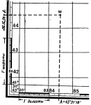
On all sides the frame has scales divided into minutes. For both latitude and longitude. Moreover, each minute is divided into 6 equal sections by dots, which correspond to 10 seconds of longitude or latitude.
Thus, in order to determine the latitude of any point M on the map, it is necessary to draw a line through this point, parallel to the lower or upper frame of the map, and read the corresponding degrees, minutes, seconds on the right or left along the latitude scale. In our example, point M has a latitude of 45°31’30”.
Similarly, drawing a vertical line through point M parallel to the lateral (closest to the given point) meridian of the border of a given sheet of the map, we read the longitude (eastern) equal to 43°31’18”.
Application to topographic map points at given geographic coordinates.
Drawing a point on a map at specified geographic coordinates is done in the reverse order. First, the indicated geographic coordinates are found on the scales, and then parallel and perpendicular lines are drawn through them. Their intersection will show a point with the given geographic coordinates.
Based on materials from the book “Map and Compass are My Friends.”
Klimenko A.I.
Many of us became familiar with such concepts as longitude and latitude in childhood thanks to the adventure novels of Stevenson and Jules Verne. People have been studying these concepts since ancient times.
In that era when there were no perfect navigation instruments in the world, it was the geographic coordinates on the map that helped sailors determine their location at sea and find their way to the desired land areas. Today, latitude and longitude are still used in many sciences and make it possible to accurately determine the position of any point on the earth's surface.
What is latitude?
Latitude is used to set the location of an object relative to the poles. The main imaginary line of the globe, the equator, passes at the same distance from and. It has zero latitude, and on both sides of it there are parallels - similar imaginary lines that conventionally intersect the planet at equal intervals. To the north of the equator there are northern latitudes, to the south, respectively, southern latitudes.
The distance between parallels is usually measured not in meters or kilometers, but in degrees, which makes it possible to more accurately determine the position of an object. There are 360 degrees in total. Latitude is measured north of the equator, that is, points located in the Northern Hemisphere have a positive latitude, and points located in the Southern Hemisphere have a negative latitude. 
For example, the north pole lies at a latitude of +90°, the south pole - -90°. Additionally, each degree is divided into 60 minutes, and minutes into 60 seconds.
What is longitude?
To find out the location of an object, it is not enough to know this place on the globe relative to the south or north. In addition to latitude, longitude is used for the full calculation, establishing the position of a point relative to east and west. If in the case of latitude the equator is taken as a basis, then longitude is calculated from the prime meridian (Greenwich), passing from the North to the South Pole through the London borough of Greenwich.
To the right and left side from the Greenwich meridian, ordinary meridians are drawn parallel to it, which meet each other at the poles. Eastern longitude is considered positive, and western longitude is negative. 
Like latitude, longitude has 360 degrees, divided into seconds and minutes. To the east of Greenwich is Eurasia, towards the west - South and North America.
What are latitude and longitude used for?
Imagine that you are sailing on a ship lost in the middle of the ocean, or moving through an endless desert, where there are no signs or signs at all. How could you explain your location to rescuers? It is latitude and longitude that help to find a person or other object anywhere on the globe, no matter where it is.
Geographic coordinates are actively used on search engine maps, in navigation, and on regular geographic maps. They are present in surveying instruments, satellite positioning systems, GPS navigators and other tools needed to determine the location of a point.
How to set geographic coordinates on a map?
To calculate the coordinates of an object on the map, you must first determine in which hemisphere it is located. Next, you should find out between which parallels the desired point, and set the exact number of degrees - they are usually written on the sides geographical map. After this, you can proceed to determining longitude, first establishing in which hemisphere the object is located relative to Greenwich. 
Determining degrees of longitude is similar to latitude. If you need to find out the location of a point in three-dimensional space, its height relative to sea level is additionally used.